Written by Jake Markey
How do you lead a conversation about something that does not exist? How can you solicit input from the public on something that’s only a figment of the imagination? Alternatively, how can the public demonstrate the future impact of something that does not yet exist?
For planners and activists alike, visualizations like maps and renderings are key communication tools to demonstrate the consequences of physical construction and change to the urban environment. Images of proposed changes to a person’s immediate environment are bound to stir some reaction, be it excitement, informed critique, or staunch resistance. At their best and paired with an intentional engagement strategy, visualizations can empower the public to provide specific, actionable feedback to a proposed project. Effective visualizations also make technical concepts, such as zoning or affordable housing tax incentives, tangible to an audience of non-experts.
But visualizations come at a cost. An effective map or digital rendering requires time, expertise, and money, which are resources often in short supply.
This is beginning to change with the advent of new generative AI tools. The cost to develop an effective visualization is in rapid decline thanks to novel AI tools that can make complex software more accessible or can even fully develop an image based on the user’s prompt. Despite limitations, these technologies can support meaningful public participation and empower a non-technical audience to provide a nuanced critique.
Visualization: A Key Tool for Community Engagement
Generations of planners and activists have developed visuals to communicate and crystalize a vision. These visuals range from simple sketches on a map to interactive websites, visuals ensure that stakeholders can be on the same page when discussing a proposed project.
The 2013 paper “Designing Public Participation Processes” provides an overview of the literature on best practices for public engagement. One notable guideline is that participation processes should “make use of information, communication, and other technologies that fit with the context and the purposes of the process.” A multi-faceted approach to communications and visualizations makes an engagement process more effective by:
- Simplifying technical concepts and expanding a project’s context
- Building a shared understanding of a proposed project’s scope
- Gathering real time feedback and facilitating community interactions
Web-based visualizations are an increasingly common tool for planners to engage citizens and depict a proposed project. Remix, an online mapping platform, is a notable example. The site empowers users to explore a large proposed project, like a bus network redesign, and leave feedback in a precise location. As a result, the site is conducive to providing specific, actionable comments. Another notable tool is InCitu, whose smartphone-based platform takes visualization further by enabling citizens to view a proposed project in augmented reality.
Visualizing a proposed project is an essential part of planning; it will happen with whatever tools are available. Prior to the widespread adoption of online tools like the ones noted previously, simple drawings could effectively demonstrate a proposed change and simplify complex topics like zoning.
One notable example of analog visualization was sparked by a proposed development on the northside of Washington Square Park in 1945. Opposing residents feared the plan, backed by a Robert Moses led City Planning Commission, would spark a building frenzy around the park and ultimately destroy the neighborhood’s quiet charm. A campaign led by the Washington Square Association argued for rezoning the neighborhood to limit unwanted growth and preserve the area in its current state. In addition to a technical study commissioned by the association, this visualization was created to demonstrate the importance of their proposal:
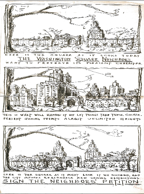
Even analog images can convey complicated concepts, like zoning, in a meaningful way. (image source- CHPC Archive)
Affordable housing is a similarly abstract concept rife with stereotypes and associations that foment public opposition. Marketing campaigns, like one in Fort Collins, Colorado, are a documented strategy for addressing these biases by depicting potential residents and the buildings. The Fort Collins campaign, which made use of computer-based graphic design, created an opposing narrative to common stereotypes that prevent affordable housing construction.
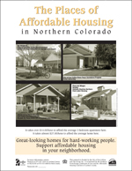
“The Faces and Places of Affordable Housing” Poster Campaign
AI Tools
Novel generative AI tools can support the creation of effective visualizations for planners and impacted communities. Tools like Midjourney and Dall-E can directly create images of proposed projects from a sufficient prompt and context.
On the other hand, chatbots like ChatGPT, Google’s Gemini, or Claude are extremely useful tools for gaining familiarity with intimidating image editing, GIS, or CAD software. Regardless of whether , these tools help us utilize other software or if they’re used as an end in themself, effective visualizations can now be made in less time and with less resources than before.
Even before the recent explosion of AI tools, advanced GIS tools have consistently become more accessible to the general public. Free and open source solutions supported by the Open Source Geospatial Foundation, such as QGIS, can be downloaded at no cost. And through the many open data resources now available, anyone can access the spatial files needed for a map. At this point, the only real requirement for the budding cartographer is the technical knowledge required for using these tools.
ChatGeoPT is a recent experiment that demonstrates how large language models can translate natural language into geoprocessing functions. The tool hints at the likely trajectory of GIS and other similar specialized software: responsive to the user’s specific, text-based commands.
Text-based map generation may be in its infancy, but image generation tools have crossed the threshold as a practical tool for depicting a vision of the future. By editing an image of the notoriously congested Brooklyn-Queens Expressway, an advocate for safer streets demonstrates how DALL-E can be used to imagine streets designed for people:
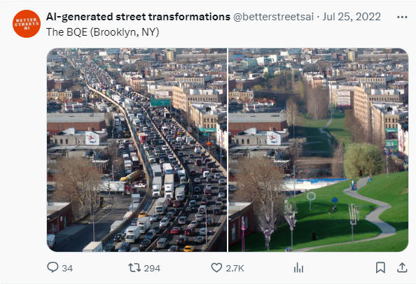
This image may not suffice for an official environmental review or as a guide for construction, but it is a powerful conversation starter for a city actively debating the future of its aging transportation infrastructure.
Like any visualization used in an engagement process, it is only useful insofar as the public is empowered to participate in the planning process meaningfully. New AI tools are an exciting progression that can help us collectively imagine and debate the future, but they’re only one piece of the puzzle! It’s important that alongside these technological advancements, we foster inclusive and accessible platforms that encourage diverse voices to contribute to the dialogue.