Imagine this scenario: You’re an urban planner meeting with a local block association to talk about making improvements to a main street. The community center’s rec room is booked, the catering arrives on-time, and the event is well-attended. You’ve prepared a nice PowerPoint presentation full of photos and renderings. Everything is going exactly as planned, until someone raises a hand to ask a question: What would it look like if, instead of a concrete median between the bike lane and street, we installed a row of planters? In fact, what if we did away with the parking lane entirely, lengthened the sidewalk by a few feet, and added some lampposts and bus shelters? Is that possible?
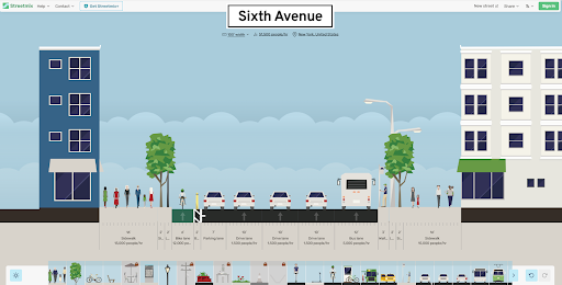
This is where Streetmix—a “collaborative civic engagement platform for urban design,” according to the website—can come in handy. Instead of instructing the attendee to use their imagination until you can go home, design new renderings, and come back a few weeks later, Streetmix’s simple interface allows users to see and make all kinds of changes in real-time. Take this mock-up of 6th Avenue in Manhattan, for example, right around the corner from the Public Works office.
With the help of simple graphics, Streetmix shows us the dimensions of the street and the estimated people-moving capacity of each segment. We can see how many people per hour the drive lanes, bus lane, bike lane, and sidewalks can accommodate, as well as the sum total at the top. The toolbar allows users to add a variety of design elements, from planters, to wayfinding maps, to food trucks, bike racks, and outdoor dining tables.
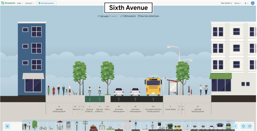
We can see that a few small changes accommodates an estimated additional 20,000 people on the streets and sidewalks. (What Streetmix doesn’t show us is how much less noise, traffic congestion, and pollution would result from such modifications.)
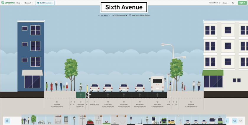
For anyone who lives in New York City, the above redesign might already seem radical enough. But Streetmix allows users, including this reviewer, to dream big—even if just for the fun of it. What might Sixth Avenue look like, and how many people could it accommodate, if we did away with car lanes entirely?
It might look, very simply, something like this.
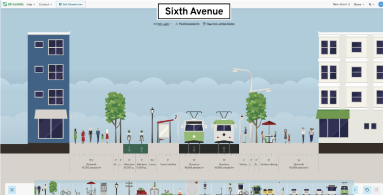
I can already hear people claiming: “but it’s more complicated than that!” And these people are right: Streetmix is a simple tool, and can only create the most basic two-dimensional renderings. The most obvious limitation of Streetmix is that you can only add design elements across a single horizontal plane, from one building’s facade to the other. It can’t take into account the very real possibility that sometimes a bike rack will follow a bench as you walk down the street, or that a street vendor might set up in the space between two trees, or that a drive lane might at some point become a turning lane. Our “redesigns” of Sixth Avenue above don’t make much sense without more information: What happens at each intersection, for example? What about delivery vehicles? To see how the diagram changes as the street continues forward, or from a bird’s eye point-of-view, you’d need to use more complicated software.
But the appeal of Streetmix remains: it allows planners and non-planners alike to experiment with street designs and see their effects by actually showing us what our ideas might look like. For many of us, the biggest roadblock towards considering some kind of change is the inability to picture it in our minds. The hope, as the team behind Streetmix continues its open-source build-out, is that the tool will democratize planning and drive discussions by providing an outlet for our imaginations.
What might your street look like?